
A Field Guide to South Wind Farm
..
Species Lists
Click the links to browse these four lists for species you’ll find at South Wind Farm:
BIRDS | TREES | MAMMALS | AMPHIBIANS & REPTILES
.
Wildlife Habitat
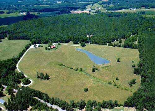
The South Wind Farm community provides a variety of habitats for both native and migratory species. The BTI campus looks out over 50 acres of open meadow with a spring-fed pond (where the Classroom Building is located).
The pond is a popular watering hole for all wildlife. There are approximately 100 acres of woodlands just beyond the meadow, interspersed with deciduous and evergreen species. A tributary of Terrells Creek bisects the woodlands. Herds of whitetail deer live on the farm, along with fox, rabbit, raccoon and coyote.
Our farm adjoins other large tracts of land to create an area for wildlife more than 500 acres in size. Within this environment, bobcat still roam (although sightings are rare).
Geography
Our location in Chatham County, North Carolina places us in the heart of the Piedmont region (GPS coordinates are N 35 46.632 x W 79 20.142). The elevation of South Wind Farm ranges from 530-610’. With a low ridgeline running across the property, the land drains into two different watersheds: Terrells Creek to the North, and Dry Creek to the South. Both flow into the Haw River, which is part of the Cape Fear River basin.
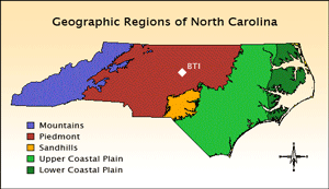 North Carolina has three main geographic regions: The Coastal Plain runs from the Atlantic Ocean to the fall line near Raleigh. The Piedmont is a broad plateau that comprises the middle of the state and extends west into the foothills. The largest Mountains are found in the far west, and include the Blue Ridge and Great Smokies.
The topography of the Piedmont is characterized by low rolling hills and elevations ranging from 200-1000 feet above sea level. Outside of urban/suburban areas, the countryside is a mixture of farmland and forests, with a network of ponds, lakes, creeks and rivers that nourish the land.
The Uwarrhie Mountains are found about an hour southwest of our campus. At elevations of 1000-1100’, they are more subtle than their counterparts to the west. However, they are the oldest mountain range in North America, and have a power and majesty all their own. A half-hour to our east is Jordan Lake. This beautiful 22-square-mile body of water is a popular State Recreation Area with public beaches and camping.